

Login/Register Subscription Info
Winter Forecast 2012-2013
November 27, 2012
Welcome to the official InstantWeatherMaps.com winter forecast for 2012-2013!
As in most winter forecasts, the first thing to talk about is the ENSO status. Last year there was a moderate La Niña whose west basis (that is, coldest anomalies in the ENSO 4 region) notably affected temperatures nationwide. One reason why my, and others', winter forecasts failed last year is that the La Niña had switched from west to central based and was looking to complete the transition to east-based as of the time that most winter forecasts came out. However, in the winter the western ENSO regions continued to cool while the eastern regions warmed dramatically -- so much that at one point there were moderate Niña conditions in region 4 and moderate Niño conditions in region 1+2. This, along with an MJO that was persistently in the horridly warm stages 5 and 6, is the main reason the cold air was pushed to Europe instead of the United States when the stratospheric warming finally removed the strong Alaska vortex that had been dominant all winter. This autumn, however, a warm-west cold-east ENSO pattern has firmly established itself in the equatorial Pacific -- case in point, region 4 has weak Niño conditions and region 1+2 has weak Niña conditions as of the last weekly update -- and this bodes very well for prospects of a colder winter in the eastern and central United States. Currently the pattern is a warm neutral ENSO approaching a borderline Niño. I expect that this winter will have a warm neutral ENSO with a strong warm-west basis. This generally means a colder winter east of the Rockies, as the ENSO itself has relatively little effect (except to slightly boost the subtropical jet) and its basis is in control of the ENSO pattern.
However, the ENSO is far from being the only factor that affects winter weather, a fact which is especially pertinent this winter in a neutral ENSO. As with last summer, this summer featured a negative AO and NAO; the NAO was the lowest ever recorded for the summer. Unlike last year, however, there was a highly negative AO and NAO in October as well -- the second-lowest AO on record and the third-lowest NAO. This is a very important distiction as the AO/NAO in October has a high correlation with the winter AO/NAO, especially in a warm-ENSO pattern. This October's Eurasian Snow Advance Index was the second highest of the past 16 years, a close second only to 2009. This index has an extremely high anticorrelation with the following winter's AO/NAO pattern, leading me to expect that the AO and NAO will both average highly negative this winter, less like last year and more like the two years before (especially 2009-2010, though the strong ENSO of that winter will obviously not be present).
The Snow Advance Index's usefulness as a predictive index is believed to be related to stratospheric disturbances which are aided by snow cover. Last winter, the stratospheric vortex was able to grow unimpeded until late January. This year, however, there are already signs of disturbances in the vortex -- a partial split is almost certain to happen in as little as one week, and an upper stratospheric warming and displacement is expected in about 2 weeks by some models. Last year, the QBO stayed positive for much longer than anyone expected, a fact which really messed with many winter forecasts. This year the QBO has stayed negative for longer than expected, and is currently slowly pushing towards neutral -- a rising negative QBO is the optimal state for experiencing stratospheric disturbances. The effects of the impending vortex split take quite some time to downwell into the AO state and later into the observed weather, however, so until mid-to-late December any cold shots that come into the US will likely be mostly unrelated to the stratosphere. These stratospheric and AO developments should make anyone think twice about using last winter as an analog.
Overall this winter will be a roller coaster ride as far as temperatures go. Phased storm systems will cause brief but sudden warm-ups followed by drastic cold plunges, especially in the eastern US. Troughs and ridges in the 500mb pattern look to be especially strong this winter, which means that "average" periods will be particularly short-lived. Weather models will oftentimes have trouble with the big picture patterns but will occasionally be able to zero in on a specific storm several days in advance. This is a winter full of paradoxes that will be very difficult to predict, especially when using conventional modeling techniques.
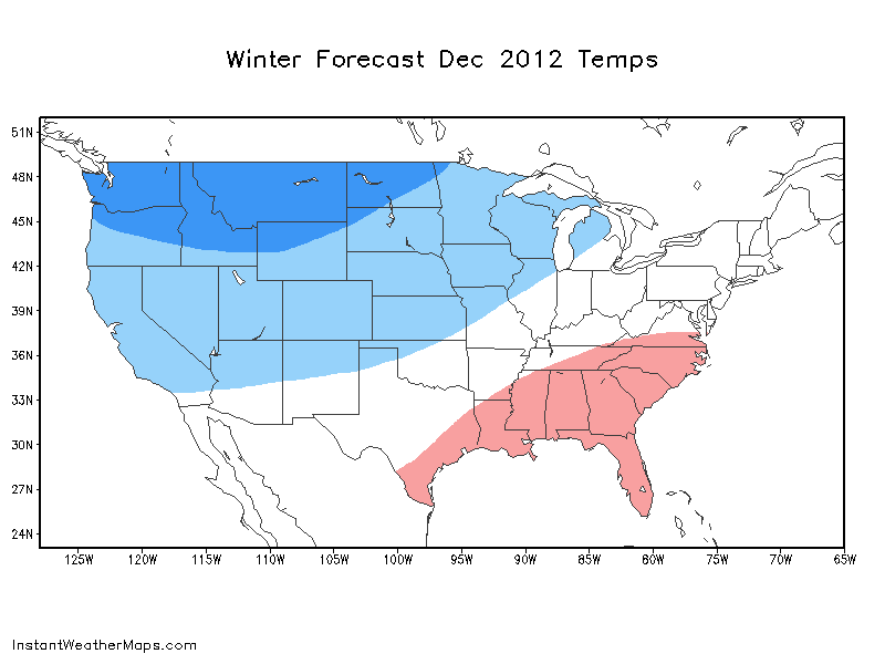
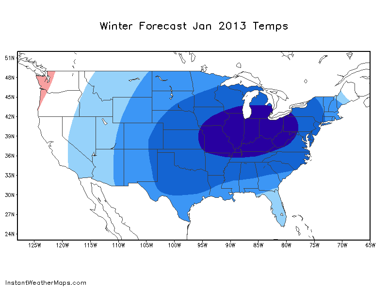
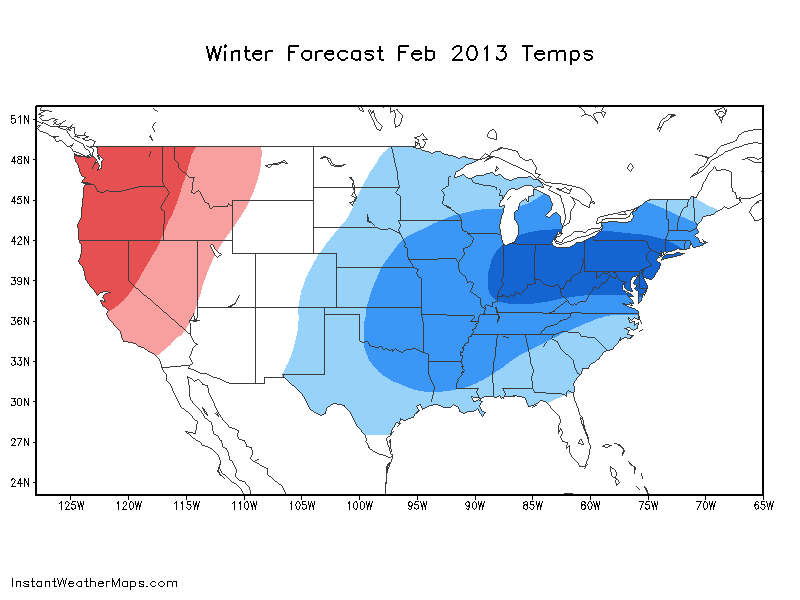
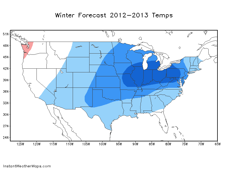
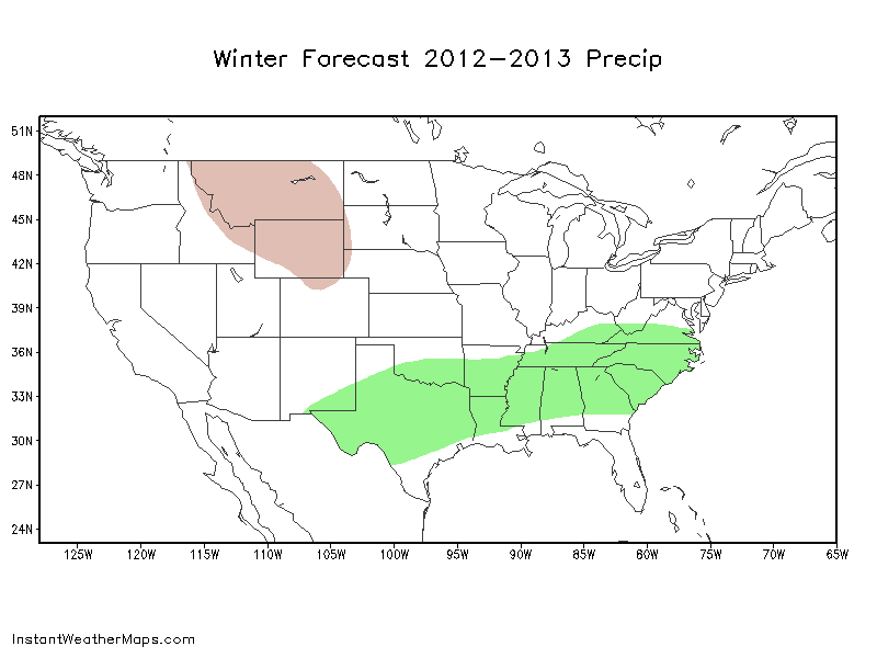
The next five maps show my general thoughts about the progession of the winter. The time period until around December 21 looks to be quite cold for the northwestern United States and warm for the southeast -- a pattern that is more reminiscent of a La Niña than a warm ENSO. Around December 21 the stratospheric vortex disturbances start to affect the general pattern, and around the same time a storm system goes through the Midwest and Northeast (according to this winter's LRC pattern of 52-53 days), sending the cold air southeastward into the central and eastern United States. With the current stratospheric developments, the concept of a prolonged January thaw which has been present for much of the last decade is laughable at best -- January looks to be one of the coldest months relative to normal in quite some time, especially in the Ohio Valley; any "thaw" will be 2-4 days in advance of a major storm system if there is one. The expected Pacific ridge will start to have a slight warming effect on the Pacific Northwest, the weak Southeast ridge will keep the core of the cold out of Florida, and the extreme Atlantic blocking will likely keep Maine near normal. By February this pattern has modified somewhat and the -EPO ridge transforms into more of a +PNA, bringing very warm conditions to the West and keeping the East cold. The central US warms some but temperatures are still below normal, especially in the Great Lakes regions. Overall this winter looks very cold for the Great Lakes regions and quite cool for much of the rest of the nation, especially between I-70 and I-80. The southern stream brings some much-needed rain to Texas and Oklahoma, while more northerly regions may have an intensifying serious drought on their hands by next summer, which may be near to slightly above normal in temperatures and near to slightly below normal in precipitation.
© 2011-2022 Instant Weather Maps, LLC. All rights reserved. | Privacy Policy | Terms & Conditions