

Login/Register Subscription Info
Winter Forecast 2011-2012
November 22, 2011
Welcome to the official InstantWeatherMaps.com winter forecast for 2011-2012! At every point in this forecast, I will explain my reasoning.
First of all, let's take care of the elephant in the room – that is, the ENSO pattern. Last year there was a moderate to borderline strong La Niña, and it had a major influence on the pattern, most notably weakening the subtropical jet stream. This year I expect for there to be a weak La Niña, which will only slightly influence the pattern. However, this will be a true east-based La Niña (last year was basin-wide), which spells colder than normal temperatures for all of the USA, with the exception of areas south and east of a straight line from Austin to Washington, DC. The coldest areas would be in the Northern Plains region if the typical East-Based La Niña pattern were to directly verify.
However, I mentioned that the La Niña's influence would be weak. The true drivers of the long-term pattern will be the Arctic Oscillation, the North Atlantic Oscillation, and the East Pacific Oscillation. A negative summer AO and NAO is associated with a negative AO and NAO the following winter. This past summer the AO was the third lowest it has ever been, and the NAO was the second lowest it has ever been. In addition, both indexes were solidly negative for each of the months of June, July, and August. This would support a solidly negative AO and NAO this winter. Solar geomagnetic activity is still low, which would suggest enhanced chances of strong blocking (negative AO). The QBO is turning from positive to negative, which could bring an interesting situation, with the AO being forced farther down by the –QBO at 30mb without the enhanced southeast ridge that a –QBO at 50mb would bring. The summer SST configuration in the north Atlantic is pointing towards a negative NAO, though not as much as it did last year. However, a deeper look reveals that this pattern is very strongly pointing towards a negative west-based NAO, that is, a blocking high between Baffin Island and Greenland. This supports cold in the eastern US way more than a negative east-based (high between Greenland and Iceland) or neutral-based (high right over Greenland) NAO does. There is some speculation that the eruption of Eyjafjallajökull slightly reduced the NAO and AO during 2010-2011. If so, then it is likely that this year's eruption of Grímsvötn will have a similar effect this winter. There is currently record cold air over Alaska and Canada, and it is only a matter of time until the pattern changes and brings this cold air down to the United States. The final consideration of these three is the EPO. A first glance at the current pattern shows that the EPO is strongly positive and has been for quite a while, with a very powerful vortex over Alaska. However, that is not supported at all by the increasingly obvious east basis of the La Niña. I expect the vortex to become a bit weaker, and, more importantly, to retrograde toward the Aleutian Islands as the month of December progresses. This seemingly small change makes a world of difference for the pattern, as it would switch the EPO from strongly positive to strongly negative once an upper-level high takes the vortex's place.
Finally, the MJO and jet streams will be key factors in the kinds of storm systems that traverse across the United States. The MJO has been uncharacteristically active for a La Niña, having stayed outside the COD for all of the last 40 days. This seems to indicate that the southern jet stream will play a much larger role this winter than it did last winter. There appears to be a Pineapple Express moisture plume from Hawaii forming as well; and, to top it all off, the Gulf of Mexico is practically an open book if the systems of the past month have anything to say about the weather this winter. Essentially the Texas and Oklahoma drought areas east of I-35 have nothing to worry about. Although this sounds very El Niño-ish, the La Niña will still show itself; the strength of the northern jet stream is nothing short of amazing, indicating that storm systems may be particularly powerful this winter, similar to last winter. With a possible blocking pattern pushing an extremely powerful northern jet into a moisture-laden southern jet, the potential for phasing is high this winter, and when it does happen, the systems will have high winds and high QPFs. Areas near I-70 east of I-35 are in for a very snowy winter if this setup verifies.
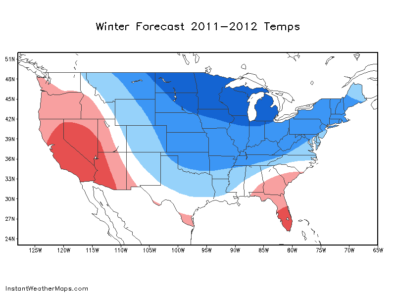
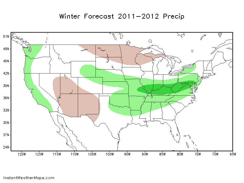
The two maps below show my general thoughts for temperatures and precipitation. This winter will likely not have the "January thaw" that has happened in the past few winters; it appears that instead the cold air will continue to build momentum through the end of the winter. There may be a flip back to an overall warm pattern in March or early April though to bring in a possibly warm and dry summer (though likely nothing like this past summer was in Oklahoma); -AO regimes tend to exaggerate seasonal extremes in much of the US.
© 2011-2022 Instant Weather Maps, LLC. All rights reserved. | Privacy Policy | Terms & Conditions